Asia
Atlas
Worldmap
Earth
Making of World Map
World Map
Physical World Map
Political World Map
World Outline Map
Symbol of geography
Tool of map making
Air Route
Agriculture map
Annual Rain fall
Big Business
Continents Map
Earthquake danger zone map
Fisheries
Forest Map
Geology & Soil
Global Warming
Gold mine map
Hotels of World
Language
Literacy
National Parks and wirldlife
Natural Resources
Sea Route
Thematic maps
Temperature and Pressure
World rivers maps
University of World
World Newspapers
World Climate
World Environmental issues
World endangered species
Water
Others
History of World Map
America
Balkan States Map
Baltic States Map
Birds populated areas
Bio-geographical regions or Biomes
Central America Political Map
Commonwealth States map
Desert Map
Indus Valley Civilization (Harappan)
Language Stats
Mountain Range Map
Pacific Ocean Map
Tiger Population map
Sea Animals
Top Ten Countries
UK Political Map
Wildlife Density
7 wonders of the world
Where is?
Where is Asia?
|
Bangladesh
Capital: Dhaka
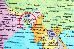
Map Bangladesh
Formerly part of Pakistan, Bangladesh came into existence in 1971. It was known as East Pakistan before its independence that was achieved after a bitter civil war with the other part of Pakistan. The war also saw India supporting the cause of Bangladesh. Bangladesh was ruled by the military dictatorship for 15 years. Though 1990 saw the restoration of democracy, the country is still politically volatile.
The topography of Bangladesh is charatcterised by the alluvial plain of the Ganges-Brahmaputra river system - the largest delta in the world. The hill tracts of Chittagong lie to the east of the delta. Flood occurs at regular intervals and people have become used to it. The country witnessed some excessive flooding, as in 1988, 1998 and 2004, which resulted in widespread loss of life and destruction of property.
Travel overview
Bangladesh whose tourist board says "Come to Bangladesh before
the tourists" is known for its exotic wildlife, ancient archeological
sites, and medieval Islamic architecture. Extensive mangrove forests
and lovely beaches await you in the country. Dhaka, the capital city,
is home to its museums, fort and distinctive culture and traditions.
Though Bangladesh wonders are many, the most celebrated tourist attractions in the country include the 17th century Lalbagh Fort and Sundarbans National Park, the largest mangrove forests in the world where you can find the world renowned Royal Bengal Tiger. Cox's Bazaar prides itself on being the world's longest and broadest beach. Mainimati Ruins, famous for its Buddhist sites, and the Buddhist monastery of Somapuri Vihara are attractions. .
Other attractions of Bangladesh include Chittagong city, Madhupur
National Park, Sylhet tea gardens, and the scenic town of Madhabkunda,
known fpr its incredible scenery and charming waterfalls. Tourists
Boat cruises in the Sunderbands National Park will; be an unforgettable
experience.
Capital: Dhaka
Location: Southern Asia
Climate: tropical; mild winter, hot, humid summer
Total Area: 144,000 sq km
Total Population: 150,448,339
Population Growth Rate: 2.056%
Sex Ratio: 1.052 male(s)/female
Literacy: 43.1%
Ethnic Groups: Bengali, others
Irrigated land: 47,250 sq km
Languages: Bangla (official, also known as Bengali), English
Time Zone: UTC+6
Currency: taka
Type of govt.: parliamentary democracy
Head of Govt.: NA
Major Political Parties: Awami League, Bangladesh Communist Party
or BCP, Bangladesh Nationalist Party or BNP, Jamaat-e-Islami Bangladesh
or JIB
Participation in International Organizations: ARF, AsDB, BIMSTEC,
C, CP, FAO, G-77, IAEA, IBRD, ICAO, ICC, ICCt (signatory), ICRM, IDA,
IDB, IFAD, IFC, IFRCS, IHO, ILO, IMF, IMO, Interpol, IOC, IOM, IPU,
ISO, ITU, ITUC, MIGA, MINURSO, MONUC, NAM, OIC, OPCW, SAARC, SACEP,
UN, UNCTAD, UNESCO, UNHCR, UNIDO, UNMEE, UNMIL, UNMIS, UNOCI, UNOMIG,
UNWTO, UPU, WCL, WCO, WFTU, WHO, WIPO, WMO, WTO
Major Agricultural Products: rice, jute, tea, wheat, sugarcane, potatoes,
tobacco, pulses, oilseeds, spices, fruit; beef, milk, poultry
Natural Resources & Minerals: natural gas, arable land, timber,
coal
Industry & Transport: cotton textiles, jute, garments, tea processing,
paper newsprint, cement, chemical fertilizer, light engineering, sugar
Airports: 16
Railways: 2,768 km
Roadways:
239,226 km
Waterways: 8,372 km
Major Trade Partners: US, Germany, UK, France, India , China, Kuwait,
Singapore, Japan, Hong Kong
Exports: $11.17 billion
Imports: $13.77 billion