Home / Asia / Afghanistan
Capital: Kabul
The strategic position of Afghanistan has always been enticed the world’s attention since ancient times. Not withstanding its rugged and forbidding terrain, the country literally translates to the 'land of the Afghans' and was known by different names in different periods of history. Bordered by Pakistan in the south and east, Iran in the west, Turkmenistan, Uzbekistan and Tajikistan in the north, and China to the east, Afghanistan is a landlocked country. Today Afghanistan is characterized by conflict and political instability. It is prudent to follow the guidelines before making a trip to the country. After the fall of the Taleban administration in 2001, the situation has improved to some extent. Bonn conference in 2001 paved the way for the establishment of a process for political reconstruction. As a result a new constitution was adopted and presidential election was held in 2004, and National Assembly elections in 2005. Hamid Karzai was inaugurated as the first democratically elected president of Afghanistan. The National Assembly came into being on 19 December 2005. The present dispensation is facing the challenge of stretching its authority beyond the capital city of Kabul as the rest of the country is again witnessing the resurgence of the hard-line groups.
Political Map Afghanistan
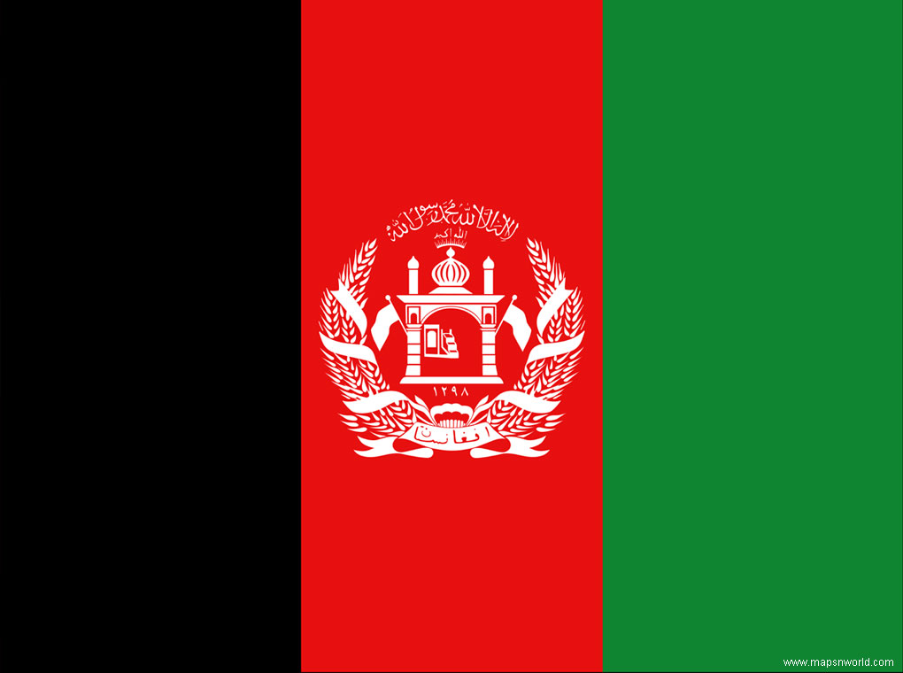
Flag Afghanistan
Afghanistan Travel
Outline Map Afghaniastan
Kabul
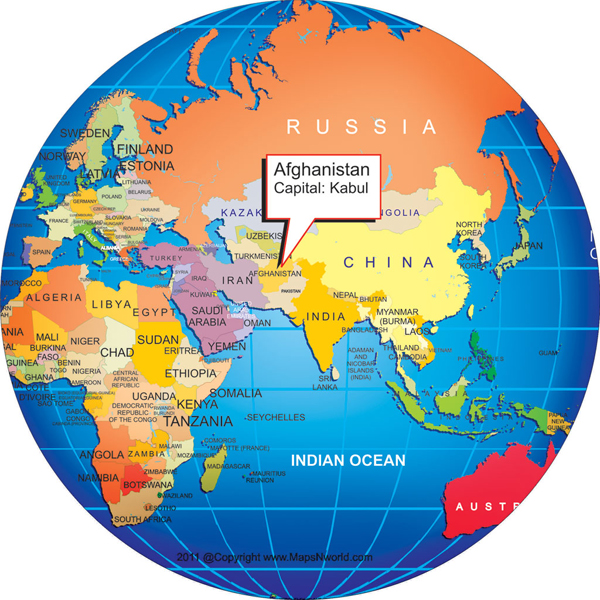
Where is Afghanistan?
Map Afghanistan
The Physical Map
Population Map
Travel Map
Geology
Natural Vegetation
Power Consumption
Oilseeds and Spices
Fruits Crop
Industrial Regions
Handicrafts Industry
Language
Afghanistan Travel
Outline
Kabul
Where is Afghanistan
Map of Afghanistan
Travel overview
Afghanistan has just emerged from years of war and civil unrest. Tourists are advised to avoid military zones, be aware of landmines and be extra-careful about security at all times. Afghanistan is known for its spectacular mountainous landscapes, ancient archeological sites, and medieval Islamic architecture. Tourist attractions in Afghanistan include the magnificent Hindu Kush and Pamir mountain ranges, the ruined capital city of Kabul, The fascinating medieval towns of Balkh, Ghazni, Mazar-e-Sharif and Kandhar are interesting places to visit. The ancient town of Bamiyan offers the opportunity to pass through the kaleidoscopic of time. The place is home to the Band-e-Amir Lake. Other tourist attractions include the 5th century fortress of Bala Hissar and City Walls in Kabul, the scenic Panjshir Valley. For adventure tourists, the country also offers excellent conditions for hiking and mountain trekking.
Tourist Places Afghanistan:
Bamiyan Buddhas: World tourist place, destroid by Taliban in 2001.
Citadel: It has been reopened after a long time and the National Mesuem of Herat situated inside it. It has restored several art effects and historical things, that attract tourists from all over the world.
Band-e-Ami: These are five lakes of found naturally in Afghanistan and a beautiful place to visit.
Khyber pass:
Kabul - the capital of Afghanistan
Balkh
Bamiyan - Buddhas remain left after the destroied by Taliban
Ghazni
Herat - here are several historical monuments are situated.
Jalalabad
Kandahar - It is also known for Kandhari pomgranate
Kunduz
Mazar-e Sharif
Band-e Amir National Park
The Khyber Pass
The Minaret of Jam
Panjshir Valley
The Salang Pass
Shamali Plain
Gardez
Afghanistan, locted in the heart of asia has much to present an adventurous traveller
but from last three decades the country is going through nation wide rebuilding process. due to the extremely dangerous security and high threat of terrorist attacks one must not prefer to travel to Afghanistan. however, there are certain things that may attract ones attention. coming across the epic country side , rugged mountains , interacting with local communities travellers can explore the great ancient civilisation of the country. some of the important cities of Afghanistan are:
Kabul - proud of its heritage the capital city located in the east of the country. A very historic city built about 4000 years ago. one can visit many places in kabul such as kabul museum, king nadir shah 's tomb, chickken street, money market, kabul zoo, shamali, paghman, istalif, darulaman palace etc.
Balkh- located in the north, known for its history of centre for the bactrian empire before the arrival of alexander the great. the city is enclosed with ancient fortifications including some of the beautiful mosques such as Shrine of Khoja Abu Nasar Parsa, Dargah of Rabia Balkhi and Noh Gonbad (Haji piyada) mosque.
Bamiyan - the main town in bamiyan province. the left over remais of buddha destroyed by taliban as an act of cultural vandallism grabs most of the tourists attention.
Ghazini - located in the south in between kabul and kyber pass. the old minarets to the north are the main accessories of the city
Herat - second largest city of Afghanistan and a gateway to iran with several interesting historical places. it is known as the diamond of asia in literature.
Kandahar - a taliban influenced ciity in the southern region. the presence of green gardens and the rivers running across the country enhances its natural beauty
Kunduz - a major city and crossing point to tajikistan.
Jalalabad - located in the east between kabul and khyber pass. many places worth visiting are presentt here.
Mazar e sharif - a staging point for trips to Afghanistan. the most famous blue mosque, also known as shrine of hazrat ali ( the place of burial of fourth calph of islam, al bin talib )is located here. it is the fourth largest city of Afghanistan
Puli Khumri - located in the heart of Afghanistan, an ancient city.
Other destinationns to visit are as follows :
Band e Amir - it is the cluster of five lakes also known as lake of jewels.
Kabul Museum - it is also known as the Afghanistan national museum. this museum built in 1920 presents finest collections of early buddhism, kushan, early islam and many other manuscripts, miniature weapons and art collections of royal families in central asia.
Khyber Pass - it is an important link between Afghanistan and pakistan. a quite adventurous place that served a important trade route between central asia and south asia in history.
Minaret of Jam - it is also called Minaret of Ghiyath al-Din Muhammad bin Sam. it is a beautiful minar located next to the hari rud river and one of the buildings listed in UNESCO's world heritage list.
Panjshir Valley - due to its astonishing natural beauty and closseness to kabul it is one of the most tourist visited destinatons in Afghanistan.
Tora Bora - also named as black dust is a cave complex in eastern Afghanistan.
salang pass - it links the road between kabul and mazar e sharif . a beautiful pass and perfect site for photography.
Gardez - a beautiful town in southeast mount valley of kabul.
Shamali Plain - a green plain that is the main source of food for central Afghanistan.
Map of Kabul:
Capital: Kabul
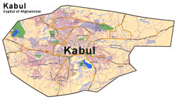
Map of Kabul
Location: Southern Asia, north and west of Pakistan, east of Iran
Climate: arid to semiarid; cold winters and hot summers
Total Area: 647,500 sq km
Total Population: 31,889,923
Population Growth Rate: 2.625%
Sex Ratio: .049 male(s)/female
Literacy: 28.1%
Ethnic Groups: Pashtun, Tajik, Hazara, Uzbek, Aimak, Turkmen, Baloch
Irrigated land: 27,200 sq km
Languages: Afghan Persian or Dari, Pashtu, Turkic languages, Balochi and Pashai, much bilingualism
Time Zone: UTC+4.5
Currency: Afghanis
Type of govt.: Islamic republic
Head of Govt.: Hamid Karzai
Major Political Parties: There are somany political parties with different agenda. Islamic Society of Afghanistan (Jamiat-e-Islami), Islamic United Party of Afghanistan (Hezeb Wahdat Islami Afghanistan ), Islamic Party Jamiat of Afghanistan (Hezbe Jamiate Islami Afghanistan), Islamic Party of Afghanistan (Hezb-i-Islami Afghanistan), National Congress Party of Afghanistan (Hezb-e-Congra-e-Mili Afghanistan), National Movement of Afghanistan (Hezb-e-Nuhzhat-e-Mili Afghanistan), National Islamic Movement of Afghanistan (Jumbish-i-Milli Islami Afghanistan), United National Front
Participation in International Organizations: AsDB, CP, ECO, FAO, G-77, IAEA, IBRD, ICAO, ICCt, ICRM, IDA, IDB, IFAD, IFC, IFRCS, ILO, IMF, Interpol, IOC, IOM, ISO (correspondent), ITU, MIGA, NAM, OIC, OPCW, OSCE (partner), SACEP, UN, UNCTAD, UNESCO, UNIDO, UNWTO, UPU, WCO, WFTU, WHO, WIPO, WMO, WTO (observer)
Major Agricultural Products: opium, wheat, fruits, nuts; wool, mutton, sheep skins, lambskins
Natural Resources & Minerals: natural gas, petroleum, coal, copper, chromite, talc, barites, sulfur, lead, zinc, iron ore, salt, precious and semiprecious stones
Industry & Transport: small-scale production of textiles, soap, furniture, shoes, fertilizer, cement; handwoven carpets; natural gas, coal, copper
Airports: 46
Roadways: 34,782 km
Waterways: 1,200 km
Major Trade Partners: US, India, Pakistan, Finland, Germany, Turkey, Turkmenistan
Exports: $471 million;
Imports: $3.87 billion

Being a landlocked country Temperaature in afghanistan varies seasonally, very cold in winterss and normall in summers. The lowest temperature record till now is -67°C in northern and highest record is 49°C. Politically, most of the areas in afghanistan has a subarctic mountain climate with dry and cold winters whereas in lowlands climate is arid and semiarid. In the valleys bordering pakistan there is a fringe effect of indian monsoon that is moist maritime tropical air in summer. Summer temperatures can be as high as 49 °C (120 °F) in accordance with record in the northern valleys. Midwinter temperatures as low as -9 °C (15 °F) are common around the 2000-m (6600-ft) level in the Hindu Kush. the temperature of the eleveted lands increases with the increase in elevation being highest at the mountains. Temperatures in the central highlands are below freezing in the winter, and snowfall is common at higher elevations. Summertime highs in lower elevations (such as Jalalabad or Mazar-e Sharif) can exceed 50°C/120°F. In higher areas such as Kabul, summer temperatures can be 30°C/90°F and winter around 0°C/30°F. The most pleasant weather in Kabul is during April, May and September. temperature variations may range freezing in the evenings to the upper 30s °C (upper 90s °F) in the daytime. Most of the precipitations falls between october and april. mountain regions receive more of the precipitations (more than 1000 mm) in the form of snow and the desert areas receive less than 100nm in a year. Frontal winds brushing in from the west may bring large sandstorms or dust storms, while the strong solar heating of the ground encourages large local whirlwinds. As for the capitall, kabul receives about 312 mm (12.3 in) of rainfall per year, or 26 mm (1 in) per month. On average there are 55 days per year with more than 0.1 mm (0.004 in) of rainfall (precipitation) or 4.6 days with a quantity of rain, sleet, snow etc. per month. an average of 1 mm (0 in) of rainfall (precipitation) occurs in the month of june leeading as the driest weather whereas an average of 71.9 mm (2.8 in) of rainfall (precipitation) occurs in the month of april leading the wettest weather in the city. the best time to visit the country afghanistan is from May to October.
Pomegranate, Kishmish, Walnut, Almond, Safron, Muskmelon, Watermelon, Fig
Afghanistan, a landlocked country located in the central asia is the 41st largest in the world in size with kabul as its capital and also the largest city situated in kabul province. Afghanistan is located on the Eurasian Tectonic Plate having a complex and varied geology. the oldest rocks are archeans following Proterozoic and Phanerozoic system. due to widely varied geological factors there is a rich heritage of minerals with 1400 in accordance withh the record. Afghanistan is believed to have some of the oldest historical mines of a precious stone lapus lazuri. from recent examinations in the late 19th century many significant resources such as copper, iron and gold, and non-metallic minerals, including halite, talc and mica. Each part of Afghanistan has a different geological history and mineral prospectivity. in north Afghanistan , the Tadjik block constitutes the southern margin of the Eurasian continental plate. during the Cimmeride Orogeny, due to the closure of the Tethys Ocean Triassic granitoids intruded Palaeozoic basement. moreover, clastic sequence deposited changes upwards to Cretaceous carbonate platform sedimentation which is now under the discovery of hydrocarbons and mineralisation of many valuable metals. the collision of the parts of northern edge of the Gondwanaland and the Tadjik block resulted in the Cimmeride Orogeny. first Farad block against the Tadjik block and then Helmand block against the Farad block. the herat fault system and the panjao suture marks the sutures of the two collisions. both the suture zones are ophiolite in nature. Pamir and West Nuristan blocks of northeast Afghanistan along with the Tadjik block are known as afghan blocks. the southeastern margin of the block is rich in precious metals. after a short period of rest tectonic plates start moving driftting india towards north toward the Eurasian plate with afghan block at its southern margin. a volcanic arc starts developing on the margin of the Eurasian plate with broadening of kandahar volcanics. kandahar volcanics were intruded by underthrusting of 'I-type' granitoids in the Helmand and West Nuristan blocks. this setting of plates is highly destined to various mineralisation ways and a large number of mineral exploration strenghten the possibility of the east-central Afghanistan region. there is no igneous activity in this region with oligocene, younger alkaline enroachments and basaltic thrust outs in the farad block and sedimentary basins within herat fault zone. it is been suggested that these rocks are derived from the layery source present underneath a zone of continental crust of northeast Afghanistan. with the beginning of the period of deposition of rocks, the marine sedimented extensions in the himalayan orogeny confined to the Tadjik block. by the tertiary times, indian collision began elevating the area above the sea level. due to the distortion of the afghan block herat fault system , chaman fault system and many other internal block boundaries reactivated. mesozoic sediments also folded and resulted in the inversion and imbrication with the palaeozoic basement. in the east of the afghan block a wide variety of tectonic plates are present. in the mesozoic era , the east nuristan volcanic arc accumulated around the boundary of eurasia proceeding with the docking of the kabul block. the kabul block consists of Lower Palaeozoic basement overlain by Mesozoic sediments with the Kabul and Khost ophiolites to the east and west respectively. it is believed that the kabul block got separated from the indian and the afghan block by oceanic crust and afterward got accumulated to the margin of afghan block. the kabul block is specifically destined for copper and chromite in its basement and ophiolites respectively. the closing block is the flexural basin on the western margin of the Indian Plate known as katawaz basin. in Afghanistan, sedimentation takes place across the country including large areas of Quaternary deposits particularly in north and southern regions of the country.
Pashto and Dari are the two official and widely spoken languages of afghanistan. these are indo european language that originated from iranian languages.Uzbek, Turkmen, Balochi, Pashayi and Nuristani are also spoken by people across the country. many languages such as Ashkunu, Kamkata-viri, Vasi-vari, Tregami and Kalasha-ala, Pamiri (Shughni, Munji, Ishkashimi and Wakhi), Brahui, Qizilbash, Aimaq, and Pashai and Kyrgyz are used by minority groups as a means of communication. in the year 1980 , regional languages were also announced as official languages in the areas where they are widely spoken. Dari is known as 'farsi' all over the country .
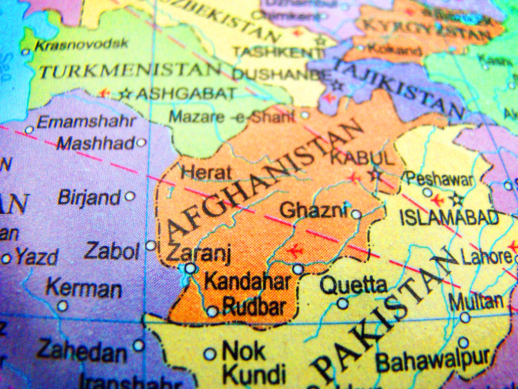
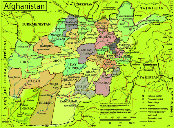
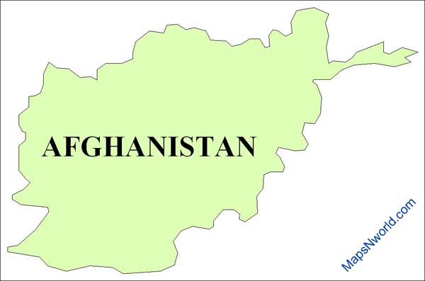
Map of Afghanistan, Afghanistan shares its border with Pakistan, Iran Tajikistan, Uzbekistan and Turkmenistan. Herat Kabul, Ghazini and Kandhar are the major cities of Afghanistan.
Zoom to Enlarge ![]()
Afghanistan Vegetation
Afghanistan situated in central aisa has a total land boundary of 5500 km and area 647.500km².it is divided into three major regions namely central highlands, southwestern plateau and northern plains area. the central highlands, part of himalayas account for two - thirds of the country area. southwestern for one fourths of the land and smaller northern plain contains the most fertile soil. land elevations following the shape of hindu kush massif slopes from northeast to southwest. there are no mountains on the southwest, north and west regions. during winters Afghanistan receives snowfall which afterward melts and run into rivers and lakes due to which the country does not experience water shortage. the massive mass of vegetation in Afghanistan is confined to main ranges and immediate offshoots whereas on terminal prolongations and distant areas it is almost absent. in safed koh, on the alpine range and its branches at a height of 1,800–3,000 m (5,900–9,800 ft) there is plentiful of forest growth surrounded by conifers as the most noble and particularly important including Cedrus deodara, Abies excelsa, Pinus longifolia, Pinus pinaster, Stone pine (the edible pine), yew, the hazel, juniper, walnut, wild peach and almond. many varieties of rose, honeysuckle, currant, gooseberry, hawthorn, rhododendron and a luxuriant herbage among of which ranunculus family is important. lemon and wild vine are found on northern mountains. the walnut and oak (evergreen, holly-leaved and kermes) slope towards secondary heights and get mixed with alder, ash, khinjak, Arbor-vitae, juniper and with species of Astragalus. Indigoferae rind dwarf laburnum is also found here. wild olive and species of rock-rose, wild privet, acacias and mimosas, barberry and Zizyphus are present down to 1000m (3,300 ft) . on the eastern side of the chain Nannerops ritchiana (which is applied to a variety of useful purposes), Bignonia or trumpet flower, sissu, Salvadora persica, verbena, acanthus, varieties of Gesnerae appears. ferns and mosses are restricted to higher ranges. most common plants are labiate, composite and umbelliferous plants. the vegetation is wholly herbal , shurbs are occational and trees almost non- existent. leguminous thorny plants of the papilionaceous suborder, such as camel-thorn (Hedysarum alhagi), Astragalus in several varieties, spiny rest-harrow (Ononis spinosa), its fibrous roots often serve as a tooth-brush; plants of the sub-order Mimosae, as the sensitive mimosa called by the natives lipad, the common wormwood certain orchids and several species of Salsola are found scattered over portions of the dreary plains of the Kandahar tablelands. The rue and wormwood generally used as domestic medicines—the former for rheumatism and neuralgia; the latter in fever, debility and dyspepsia, as well as for a vermifuge. The lipad, due to its nauseous odour is believed to keep off evil spirits. In some places, occupying the sides and hollows of ravines, it is found the Rose Bay, called in Persian khar-zarah, or ass-bane, the wild laburnum and various Indigoferae. mulberry, willow and populus ash are ocassionally cultivated by man. in last several decades, ninety percent of forests in Afghanistan ahave been depleted and their timber is exported to Pakistan as a result of which the forests may be subjected to soil erosion and desertification. the Karzai administration and international organizations havve taken the charge of this problem and are helping to overcome it by planting millions of saplings. the maple trees are also being planted during the last decade in the kabul city.
Enlarge view High resolution free map download for educational and other purpose.

Where is Afghanistan on the Globe? Where is Afghanistan on the world map? where is Afghanistan on the Earth? The world globe image showing answer of all the inquiries and you can find Afghanistan on this Globe
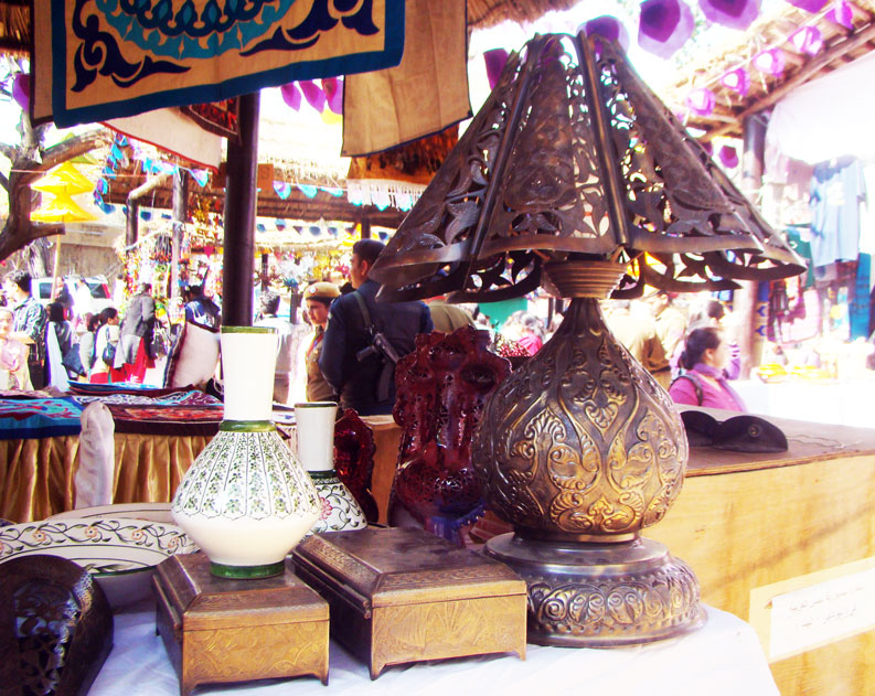
Handicrafts industry of Afghanistan is the powerful business in afghanistan for livelyhood. People make different kind of handicrafts items, like t-lights, lentern, candle holders. Brass metal products are also in high demads, copper handicrafts items also a beautiful attractions. stone jewelry, blue stone jewelry is very famous in afghanistan, however some other stones jewellery is also available. Craftsmen make stone pottery with decorative colours and designs on them.
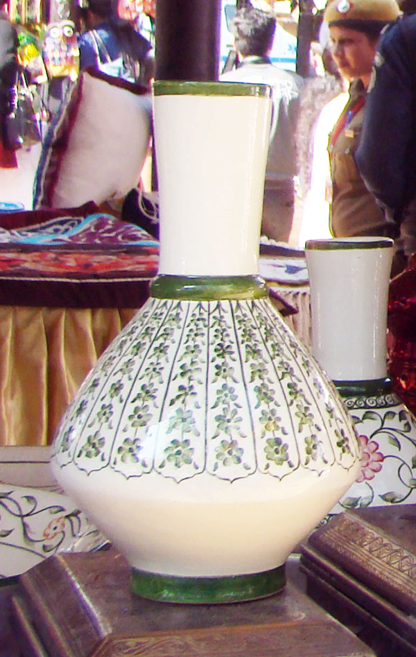
Flower vase known as stone pottery hand painted with floral green designs
Lentern made of brass metal hand crafted designs

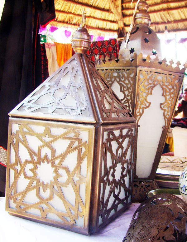
wall hangings for light decoration, metal crafts antique designs
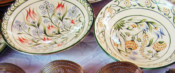
stone pottery designs of bowl with hand painted design
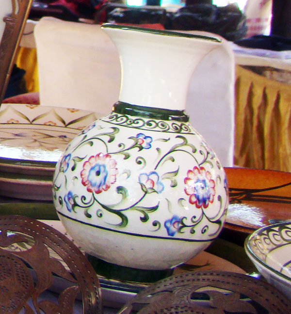
Flower vase beautifully done with colours and floral designs
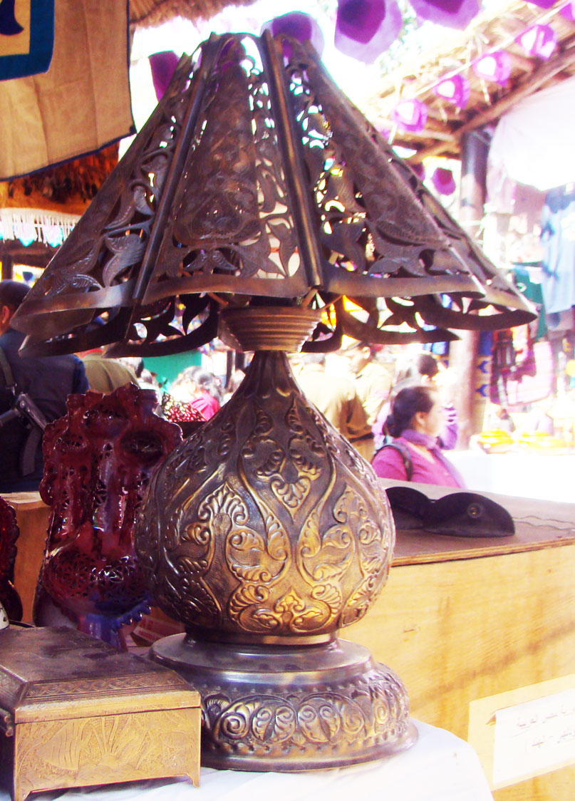
Tablke lamp, handicraft item fully made by hand engraving antique finish
Natural resources and Handicrafts industry of Afghanistan is the powerful business in afghanistan for livelyhood.

Afghanistan Outline Map, Outline map of Afghanistan, Afghanistan the country of mughals, history tells us story of Afghanistal strugles. Everybody knows about kings of Afghanistan and their wars. Indian culture is full of Mughal influance, Europe also have the influance of Afghanistan and their culture. This is the outline map of Afghanistan.
Africa | Asia | Europe | North America | South America | Oceania Australia | Antarctica | List of All Countries
|
|