Atlas
Earth
Making of World Map
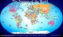
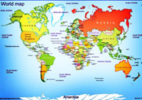
World Map
Physical World Map
Political World Map
World Outline Map
Symbol of geography
Tool of map making
Air Route
Agriculture map
Annual Rain fall
Big Business
Continents Map
Earthquake danger zone map
Fisheries
Forest Map
Geology & Soil
Global Warming
Gold mine map
Hotels of World
Language
Literacy
National Parks and wirldlife
Natural Resources
Sea Route
Thematic maps
Temperature and Pressure
World rivers maps
University of World
World Newspapers
World Climate
World Environmental issues
World endangered species
Water
Africa
African wildlife map
Travel map Africa
more...
Asia
Physical Asia Map
Asia Population Density
Industries Map
Climate
Natural Resources
Agricultural Map of Asia
more...
Europe
Political Europe
Physical Europe Map
Europe Countries
more..
North America
Political North America
Physical North America Map
more...
South America
Physical Map
more...
Oceania Australia
Agricultural Map
Countries of Australia
Polar Regions
more...
Antarctica Region
Antarctica
Arctic
Globe
Globe with South America
Globe with Asia
World Globe Image
more...
History of World Map
America
Balkan States Map
Baltic States Map
Birds populated areas
Bio-geographical regions or Biomes
Central America Political Map
Commonwealth States map
Desert Map
Indus Valley Civilization (Harappan)
Language Stats
Mountain Range Map
Pacific Ocean Map
Tiger Population map
Sea Animals
Top Ten Countries
UK Political Map
Wildlife Density
7 wonders of the world
Where is?
Where is America?
Where is Alabama?
Where is India?
Where is Libya?
Where is Egypt?
Where is France?
|
How to create world map
World map purpose is to show places on earth as they appear in their true location, in terms of latitude and longitude. Cartographers use a technique of transforming the curved earth onto a flat surface that is called projection. It would have very difficult to project globe into flat map to preserve the accuracy of all aspects. The distortion of one can affect other properties of globe.
So cartographers used three type of projection to show accuracy of different aspects of map. Cylindrical projections, conic projections and Azimuthal projections.
Cylindrical projections are useful to showing whole world;