Political Map India
india Political map have all Indian geographical information, state boundaries and their location in India political map. India is one of the 10 largest and most populous countries in the world, Delhi is the capital of India. Political map India describes all political devided states of India with their exact locations.
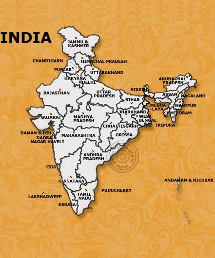
Official Political Map India (Copyright©2005
NIC govt. of Idnia)
India has devided in 29 States and 7 union terretories of India. According to location India can be describe through directions. North India, East India, South India and west India.
North West India:
Regions wise north western region share boundaries with Himalayas ranges, the icy Ladakh and the beautiful Jammu and Kashmir. The state Himachal Pradesh serve with its beautiful hill stations and Punjab and Haryana states add wealth by agricultural production which make pride to India.
Chandigarh, Haryana, Himachal Pradesh, Jammu and Kashmir and Punjab
North India:
Northern India have Delhi the capital of India, it has been a center of political power of India for centuries. Delhi has historical memories through monuments and other historical places. Delhi known as main commercial center for north India and also known for its political values. Uttarpradesh is also known for agricultural state and it has the largest population in India. Ganga is the major river flows through the Uttrakhand - Uttarpradesh - Bengal and Bihar.
Delhi, Uttarakhand, Uttarpradesh.
West India:
Western regions of India have Gujarat and Maharashtra the most commercialised states of India. Rajasthan has become biggest state with largest area and rich by mineral resources and known for its tourism values. Portuguese culture can be seen at the western political region of India.
Daman and Diu, Gujarat, Maharashtra, Rajasthan.
Central India:
Central India have Madhya Pradesh and Chhattisgarh the heart of India, have wildlife centuries and forest.
Madhyapradesh, Chhattisgarh.
South India:
South India with highest rate of literacy in India, cultural rich, Hyderabad and Bangalore are well known as high-tech city of south India. Karnataka and Kerala are known for their spices cultivation, tea and coffee plantation. Bay of Bengal, Indian ocean and Arabian sea take the pleasure by touching the boundaries of South Indian regions and enjoy the moments.
Andhrapradesh, Goa, Karnataka, Kerala, Puducherry and Tamilnadu.
East India:
Eastern India has variety of political information, it has oldest universities at Nalanda Bihar, Jharkhand rich in minerals, Orissa has temples and beaches. West Bengal has Darjeeling tea gardens, Himalayas in the north and Bay of Bengal in the south. Kolkata the capital of West Bengal has been well known since British period.
Bihar, Jharkhand, Orissa, Sikkim, West Bengal.
North East India:
Seven sisters the name come and tell us about north eastern states. Covered with Himalayas ranges on top, rich with several tribal cultures, bamboo crafts and wildlife and national parks the home for tigers and rhinasourus. Assam is the largest states have brahmputra river. The Cherapunji known for highest rainfall.
Arunachal Pradesh, Assam, Manipur, Meghalaya, Mizoram, Nagaland, Tripura
Islands:
Andaman and Nicobar Islands and Lakshadweep in the Bay of Bengal make their presence by several tribal species and coral islands, and are well known for its unspoilt beaches attract thousands of tourists every year.
Andaman and Nicobar Island, Lakshadweep
Facts and Figures:
India
Capital: New Delhi
Total Area: 3287590 sq km
States: 28
Union Territories: 7
Largest State: Rajasthan (Largest area)
Smallest State: Goa (area)
Highest Populous State: Uttar Pradesh
Lowest Populous State: Sikkim
District: 622
Highest literacy:
Lowest Literacy rate:
Languages:
Most speak-able language:
Religions:
Biggest Religion: Hindu
Smallest Religion
Largest State (Agriculture)
Largest Wildlife and National Park:
Largest Lake:
Largest River:
Highest Mountain: Averest
Famous tourist destinations: Refer to India Travel Map
Political map of
india including:
Political maps of India ! Political
map of Delhi, political map of rajasthan, travel map of goa, political map
of himachal
pradesh, political map of Jammu and kashmir, political map of Punjab, political
map of haryana, political map of uttarpradesh,
political map of gujarat, political map of bihar, political map of madhya pradesh,
political map of Maharashtra, travel map of Mumbai, political map of orissa, political map of Andhra pradesh, political
map of karnataka, political map of bangalore,
political map of kerala, political map of pondichery, political map of west bengal,
political map of nort India. political map of Mizoram, political map of assam, political
map of Tripura, political map of manipur,
political map of Nagaland, political map ofSikkim,political map of arunanchal
pradesh.
Maps of India
Political Map of India
Travel Map of India
Road Map of India
Travel Map of Delhi
Travel Map Mumbai
Rajasthan Travel Map
Gujarat
Maps
Kerala
Map
Jammu
and Kashmir Map
Himachal
Pradesh Map
Punjab
Map
Uttar
Pradesh Map
Map
of Uttranchal
Maharashtra
Map
Orissa
Map
Map
of Madhya Pradesh
Map
of Andhrapradesh
Karnataka
Map
Tamilnadu
Map
Map
of Jharkhand
Map
of Bihar
Map
of Chhattisgarh
Map
of Arunachal Pradesh
Map
of Assam India
Map
of Nagaland
Map
of Meghalaya
Map
of Mizoram
Map
of Manipur
Map
of Tripura
Some of the most searchable map
Delhi
map
Agra
travel map of India
Travel
map of Rajasthan India
Travel
map of Goa
Himalayas
map
Travel
map of Kerala
Haryana
map
Travel
map of mumbai
Pin
code zones
Distance
charts
Map of Neibour countries
Map of Nepal
Map
of Bagladesh
Map of
Pakistan
Map of Bhutan